

劳拉正以4级飓风接近墨西哥湾海岸飓风据国家飓风中心称,预计在一些地区会出现“无法抵御的风暴潮”。
NHC在一份声明中说:“不可救药的风暴潮,伴随着巨大的破坏性海浪,将从得克萨斯州的海缘州立公园,到路易斯安那州的沿海城市,包括卡尔卡西乌湖和萨宾湖,造成灾难性的破坏。”“这种巨浪可能会从紧邻的海岸线向内陆渗透30英里。只剩下几个小时来保护生命和财产,所有行动都应迅速完成。”
NHC说,得克萨斯州东部和路易斯安那州西部的部分地区预计将出现“灾难性的风力破坏”,特别是在风暴眼墙于周四早晨登陆的地方。受影响地区的居民奉命撤离并被敦促做好准备应对“大范围的破坏性阵风”,这种阵风将在这些地区的内陆蔓延开来。
乔恩·沙普利/美联社
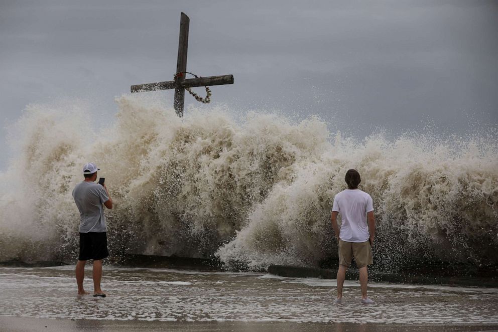
2020年8月26日,德克萨斯州的高岛,马克·奥尔姆斯(左)和亨特·克拉克(右)看着劳拉飓风外围的海浪冲击海岸。
以下是今天新闻的发展。一直是东方。请刷新此页面进行更新。
晚上8:37:警长对那些不撤离的人发出了严厉的警告
路易斯安那州朱砂教区的警长办公室对那些在风暴到来之前决定不撤离的人并没有装腔作势。
警长办公室在社交媒体上发布消息称:“那些选择留下来面对这场非常危险的风暴的人必须明白,救援工作不能也不会在风暴和巨浪过去之后才开始,而且这样做是安全的。”“请撤离,如果您选择留下,而我们无法联系到您,请写下您的姓名、地址、社会安全号码和最近的亲属,然后将它放在您的口袋中的一个拉链包中。”
“祈祷它不会到这一步!”警长办公室补充道。
朱砂教区和卡梅伦教区位于该州西南角的墨西哥湾沿岸,很可能会遭受该州最严重的风暴袭击。
警方已下令强制疏散这些教区的许多地区,并下令从当地时间晚上9点至凌晨5点实施宵禁,劳拉将于周四凌晨登陆。
下午7:52:随着风暴转向北方,风速增加到每小时150英里
随着飓风劳拉接近德克萨斯州和路易斯安那州的海岸,飓风劳拉的持续风速已经增加到每小时150英里。
风暴在路易斯安那州查尔斯湖以南约120英里,在德克萨斯州阿瑟港东南偏南同样的距离,继续向墨西哥湾推进。
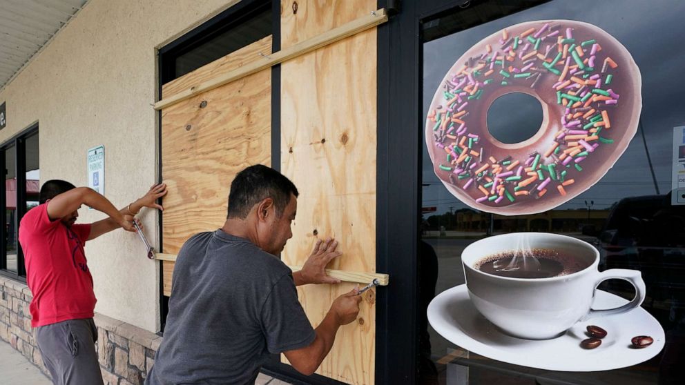
阿德里亚·拉蒂夫/路透社
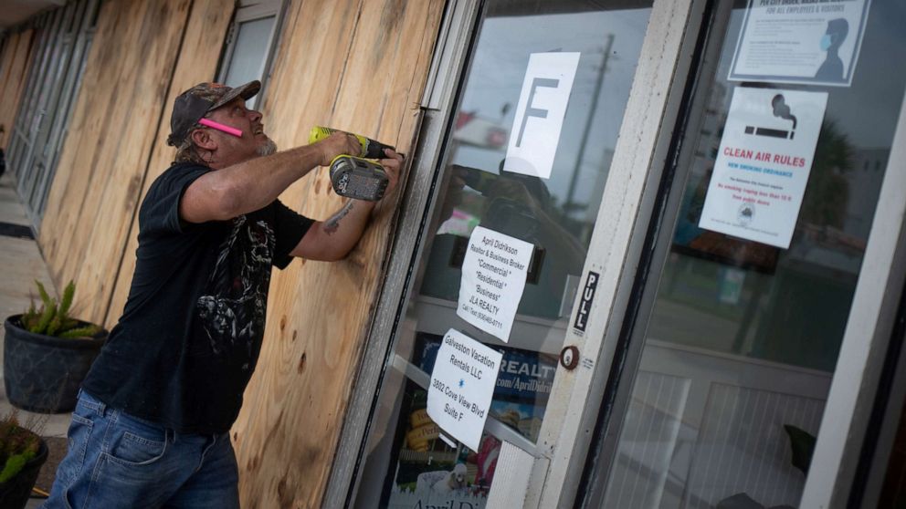
2020年8月26日,德克萨斯州加尔维斯顿,48岁的当地居民罗伯特·索耶在劳拉飓风到来之前登上了企业。
劳拉开始转向更北的方向,以每小时15英里的速度向西北偏北移动。
下午7:06:风暴临近,卡梅伦教区采取一切预防措施
路易斯安那州卡梅伦教区的官员表示,随着劳拉的到来,该地区正面临最糟糕的情况。
在接受美国广播公司采访时,卡梅伦教区代工助理主任阿什利布勒说,教区正在采取一切预防措施,因为预测表明,它可能会受到风暴的冲击。
Buller说,该教区大部分是沼泽地,是大约7000名居民的家,其中大部分人听从了撤离的警告。
布勒说,当局知道大约有150名居民选择留下来,官员们有他们的联系信息,一旦安全,他们可以派搜救人员去检查他们。
布勒说,所有的紧急行动都已转移到邻近的卡尔卡西乌教区的代工办公室。
下午5:51:龙卷风将构成额外的威胁
除了飓风条件,预报员称劳拉路径上的居民应该在风暴接近登陆时留意可能的龙卷风。
由于劳拉的力量,今晚几个龙卷风的威胁越来越大,并持续到路易斯安那州中部的部分地区。
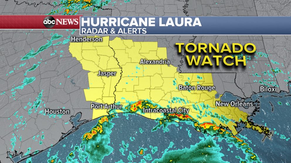
由于劳拉飓风的强度,从东德克萨斯州到路易斯安那州中部部分地区的龙卷风威胁越来越大。
路易斯安那州的派恩考特维尔至少有一次龙卷风的报告,但是没有立即报告损失。
龙卷风警报在几个地区生效,包括德克萨斯州的亚瑟港、路易斯安那州的亚历山大和路易斯安那州的巴吞鲁日。
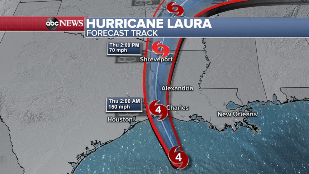
下午5:20:预计在美国东部时间上午2-5点登陆
根据最新观察,飓风劳拉预计将在美国东部时间凌晨2点至5点登陆。
随着风暴向德克萨斯州和路易斯安那州海岸移动,墨西哥湾的风力和水位都在上升。
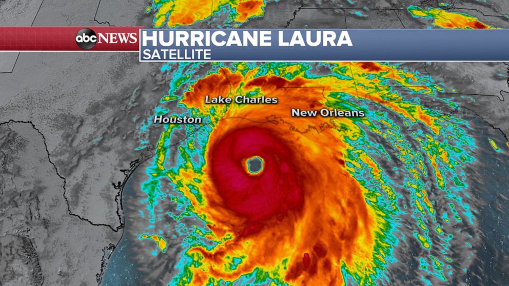
美国广播公司新闻
2020年8月26日,劳拉飓风出现在卫星上,风暴中心位于洛杉矶查尔斯湖以南约155英里处。
据NHC报道,风暴在路易斯安那州查尔斯湖以南约155英里处,在得克萨斯州亚瑟港东南偏南同样的距离。风暴眼有400多英里宽。
随着风暴以每小时15英里的速度向西北方向移动,最大持续风速继续达到每小时145英里。
下午4:42:联邦应急管理局,红十字会正在准备风暴
联邦应急管理局官员表示,他们准备在路易斯安那州和得克萨斯州进行大规模救援,近600名训练有素的救灾人员随时待命,支持受飓风威胁的社区。
官员们说,红十字会还在墨西哥湾沿岸预先部署了避难所和救援物资,如果需要,还会有更多的工作人员待命。
美国广播公司新闻
劳拉飓风预计将作为4级飓风登陆,持续风速约为每小时150英里。
美国红十字会路易斯安那州地区负责人乔舒亚·约阿希姆说:“在过去的几天里,我们的志愿者们一直在不知疲倦地工作,在全州范围内部署物资和避难所小组。”“随着风暴的转移,我们也跟着转移,并随时准备满足路易斯安那州受灾民众的紧急需求。”
紧急事务官员说,多达5000人被安置在紧急住所,包括避难所和旅馆。
下午3点24分:路易斯安那州的卡梅伦教区预计将被淹没
路易斯安那州州长约翰·贝尔·爱德华兹敦促该州西南部的居民特别关注周四凌晨登陆卡梅伦教区的风暴。
州长说飓风可能会带来自1957年以来居民从未见过的风暴潮。
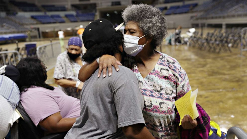
乔·雷德尔/盖蒂影像公司
2020年8月26日,在路易斯安那州查尔斯湖,劳拉飓风到来之前,德米特里·布什内尔和她的侄女拥抱在一起,他们和其他疏散人员正准备登上一辆公共汽车,由当地和州政府官员进行疏散。
州长说,该州已经启动了整个国民警卫队,这是“多年来”没有做过的事情。
爱德华兹告诉记者:“这是一场非常严重的风暴——我想我从来没有召开过像现在这样严肃的新闻发布会。”“我们州已经几十年没见过这样的风暴潮了。风速也是如此。”
气象预报员称居民应该期待看到高达18-20英尺的风暴潮。根据NHC的说法,卡梅隆教区的大部分人在某个时候会完全淹没在水下。
该州表示,已经为有需要的居民预留了2000个酒店房间。周二晚上,它在酒店房间里安置了大约800人。
下午2:26:风暴取消航班时,主要航空公司发布豁免
美国所有主要航空公司——联合航空、西南航空、达美航空、美国航空和捷蓝航空——都发布了天气豁免,允许旅客免费调整可能受劳拉飓风影响的航班。
据报道,目前有643次与风暴相关的航班取消飞行感知。
今天超过400个取消的航班在休斯顿布什国际机场,约占其航班总数的60%。
下午2点14分:德克萨斯州州长说“远离危险”
德克萨斯州在该州的灾难声明中又增加了三个县,覆盖了东德克萨斯州的大部分地区,使总数达到36个。
德克萨斯州州长格雷格·阿博特在一次新闻发布会上说:“我强烈要求任何处于危险之中的人都要脱离危险。”“因为这场风暴的力量,如果你无法或无法摆脱伤害的方式...在近24小时的时间里,救援人员和救援人员将无法进入现场,以任何方式帮助您。”
当局称,国家已投入400辆公共汽车、38架飞机、82艘船只和202辆高调车辆用于救灾。它还订购了60辆救护车和另外75辆辅助运输车辆来帮助运送居民。
已经有5000多人得到了庇护,官员们正在为更多人做准备。
预计的风暴潮,被官员描述为“不可救药”,可能会继续向内陆移动约30英里。
下午1:52:劳拉现在是四级风暴
国家飓风中心称,劳拉已经增强为4级飓风,最大持续风速为每小时140英里,这使得它“极其危险”。
风暴中心位于路易斯安那州查尔斯湖东南约200英里处,德克萨斯州亚瑟港东南约200英里处。
国家飓风中心称,今晚这场风暴将会给墨西哥湾沿岸带来灾难性的风暴潮、强风和骤发洪水。
当局称,保护生命和财产的时间所剩无几。
下午12:56:路易斯安那州官员预计暴风雨会带来灾难性事件
路易斯安那州的原始设备制造商官员直截了当地对居民说:离开,现在就离开。
在劳拉登陆前的最后一次简报中,路易斯安那州卡尔卡西乌教区的官员说,他们预计风暴会带来灾难性的事件。
莱克市长尼克·亨特说:“除了把人们从家里拉出来,我们已经尽了一切努力把人们从卡尔卡西乌教区救出来。”“尽管这让我很痛苦,但我们很快就到了你不得不蹲下的地步。公共安全将无法应对。”
警长托尼·曼库索说,虽然他们可以保护财产免受抢劫,但他们不能保护房屋免受风和风暴潮的袭击,这两种灾害预计都将远远超过2005年飓风丽塔造成的破坏性影响。
他也恳求人们离开,现在就离开。
他说:“在我的房子里没有什么东西是如此重要,我会留在我的房子里。”“我很想离开。这不是我的选择。这是你的选择。”
除了那些开着自己的车离开的人,800多人已经被公共汽车送出了这个地区。
下午12:01:风暴为3级,风速125英里每小时
劳拉的风速为每小时125英里,预计将达到每小时145英里。
该风暴目前为3级,如果风力如预期增加,预计将达到4级。
休斯顿市长西尔维斯特·特纳在接受美国广播公司采访时说,他在周二早上醒来时发现劳拉的足迹已经向西移动了一点,更靠近休斯顿,这个拥有700万人口的美国第四大城市。
休斯顿和哈里斯县的官员敦促居民远离道路,这样疏散人群就可以进入高速公路。当地官员敦促风暴路径上的所有居民给油箱和发电机加满油。
市长敦促人们不要惊慌。市政府官员说,他们不认为劳拉会是另一个哈维飓风或伊梅尔达热带风暴,这两个飓风都导致了灾难性的洪水。然而,他们确实预计这场风暴将是一次快速移动的风事件,可能会带来风暴潮、结构性破坏和停电。
使情况更加复杂的是新冠肺炎这就是为什么特纳告诉居民储备必要的食物,用品和个人防护装备。他说,他预计新冠肺炎测试将暂停,直到风暴过后,该市不会像过去几年那样开放大规模避难所。
劳拉让墨西哥湾沿岸的人们猜测了几天,因为预计的路线还在继续变化。气象预报员称,风暴甚至可能在周三晚间或周四早些时候在德克萨斯州和路易斯安那州边境附近登陆前增强为四级。
Hurricane Laura live updates: Sheriff has grim advice for those who don't evacuate
Laura is approaching the Gulf Coast as a Category 4hurricanewith "unsurvivable storm surge" expected in some areas, according to the National Hurricane Center.
"Unsurvivable storm surge with large and destructive waves will cause catastrophic damage from Sea Rim State Park, Texas, to Intracoastal City, Louisiana, including Calcasieu and Sabine Lakes," the NHC said in a statement. "This surge could penetrate up to 30 miles inland from the immediate coastline. Only a few hours remain to protect life and property and all actions should be rushed to completion."
Parts of eastern Texas and western Louisiana are forecast to see "catastrophic wind damage," especially in places where the storm's eyewall makes landfall early Thursday morning, the NHC said. Residents in affected areas are beinginstructed to evacuateand are urged to brace for "widespread damaging wind gusts" that will spread well inland across parts of those areas.
Mark Allums, left, and Hunter Clark watch waves crash ashore as outer bands from Hurricane Laura begin to hit the coast, Aug. 26, 2020, in High Island, Texas.
Here's how the news is developing today. All times Eastern. Please refresh this page for updates.
8:37 p.m.: Sheriff has stark warning for those who don't evacuate
The sheriff's office in Louisiana's Vermilion Parish isn't mincing words for those who decide not to evacuate before the storm's arrival.
"Those choosing to stay and face this very dangerous storm must understand that rescue efforts cannot and will not begin until after storm and surge has passed and it is safe to do so," the sheriff's office posted to social media. "Please evacuate and if you choose to stay and we can’t get to you, write your name, address, social security number and next of kin and put it a ziplock bag in your pocket."
"Praying that it does not come to this!" the sheriff's office added.
Vermilion Parish and Cameron Parish, which sit on the Gulf Coast in the southwest corner of the state, are likely to get the worst of the storm in the Bayou State.
Police have ordered mandatory evacuations for numerous areas in those parishes, and a curfew has been ordered from 9 p.m. local time until 5 a.m. as Laura approaches landfall early Thursday morning.
7:52 p.m.: Winds increase to 150 mph as storm turns northward
Hurricane Laura's sustained winds have increased to 150 mph as the storm approaches the coast of Texas and Louisiana.
The storm is about 120 miles south of Lake Charles, Louisiana, and the same distance south-southeast of Port Arthur, Texas, as it continues its push toward the Gulf Coast.
Local resident Robert Sawyer, 48, boards up businesses ahead of Hurricane Laura in Galveston, Texas, Aug. 26, 2020.
Laura is beginning a more northward turn, moving at 15 mph toward the north-northwest.
7:06 p.m.: Cameron Parish taking all precautions as storm nears
Officials in Cameron Parish, Louisiana, say the area is bracing for the worst as Laura approaches.
In an interview with ABC News, Cameron Parish Assistant Director of OEM Ashley Buller said the parish is taking all precautions as projections indicate that it could get the brunt of the storm.
The parish, much of which is marshy bayou, is home to about 7,000 residents, most of whom have heeded the warnings to evacuate, Buller said.
Authorities know of about 150 residents who have opted to stay behind, Buller said, and officials have their contact information so they can send search-and-rescue responders to check on them once it's safe to do so.
All emergency operations have been moved to the OEM offices in neighboring Calcasieu Parish, Buller said.
5:51 p.m.: Tornadoes will pose additional threat
In addition to hurricane conditions, forecasters says residents in Laura's path should be on the lookout for possible tornadoes as the storm approaches landfall.
Due to Laura's strength, there is the increasing threat of several tornadoes this evening and continuing overnight across parts of Central Louisiana.
Due to the strength of Hurricane Laura, there is the increasing threat of tornadoes from East Texas to across parts of central Louisiana.
There was at least one reported tornado in Paincourtville, Louisiana, but there no damage was immediately reported.
A tornado watch is in effect for several areas, including Port Arthur, Texas, Alexandria, Louisiana and Baton Rouge, Louisiana.
5:20 p.m.: Landfall expected between 2-5 a.m. ET
Hurricane Laura is expected to strike land between 2-5 a.m. ET based on the latest observations.
Wind and water levels in the gulf are increasing as the storm makes its way toward the Texas and Louisiana coast.
Hurricane Laura is seen on satellite on Aug. 26, 2020, with the center of the storm about 155 miles south of Lake Charles, La.
The storm is about 155 miles south of Lake Charles, Louisiana, and the same distance south-southeast of Port Arthur, Texas, according to the NHC. The eye of the storm is more than 400 miles wide.
Maximum sustained winds continue to hit 145 mph as the storm heads northwest at 15 mph.
4:42 p.m.: FEMA, Red Cross preparing for storm
FEMA officials say they're prepared to stage a large response across Louisiana and Texas, with nearly 600 trained disaster workers on hand to support communities threatened by the hurricane.
The Red Cross has also pre-positioned shelter and relief supplies along the Gulf Coast, and additional workers are standing by if needed, officials said.
Hurricane Laura is forecast to make landfall as a Category 4 hurricane with sustained winds around 150 mph.
"Over the past few days our volunteers have been working tirelessly to position supplies and shelter teams across the state," American Red Cross Louisiana Regional Executive Joshua Joachim said. "As the storms shift, we shift with them and remain prepared to meet the immediate needs of those impacted across Louisiana."
As many as 5,000 people are being housed in emergency lodgings, including shelters and hotel, emergency officials said.
3:24 p.m.: Louisiana's Cameron Parish expected to be underwater
Louisiana Gov. John Bel Edwards is urging residents in the southwestern part of the state to pay especially close attention to the storm as it approaches landfall in Cameron Parish early Thursday morning.
The governor said the hurricane could bring storm surges that residents haven't seen since a 1957.
Demeteri Bushnell gets a hug from her great niece as they and other evacuees prepare to board a bus as they are evacuated by local and state government officials before the arrival of Hurricane Laura, on Aug. 26, 2020, in Lake Charles, Louisiana.
The state has activated its entire National Guard, something it hasn't done in "many years," according to the governor.
"This is a very serious storm -- I don't think I have ever held a press conference to take something as seriously as I am right now," Edwards told reporters. "Our state hasn't seen a storm surge like this in many decades. Same with wind speeds."
Forecasters say residents should expect to seestorm surge of up to 18-20 feet.The majority of Cameron Parish will be totally underwater at some point, according to the NHC.
The state said it has reserved 2,000 hotel rooms for residents in need. On Tuesday night it put up some 800 people in hotel rooms.
2:26 p.m.: Major airlines issue waivers as storm cancels flights
All major U.S. airlines -- United, Southwest, Delta, American and JetBlue -- have issued weather waivers to allow travelers to adjust flights potentially impacted by Hurricane Laura without fees.
There are currently 643 storm-related flight cancellations, according toFlightAware.
More than 400 of today's cancellations are at Houston Bush International Airport, representing about 60% of their total flights.
2:14 p.m.: Texas governor says to "get out of harm's way"
Texas has added three more counties to the state's disaster declaration, covering most of East Texas and bringing the total number to 36.
"I urge anyone in harm's way to get out of harm's way," Texas Gov. Greg Abbott said at a briefing. "Because of the power of this storm, if you are unable or do not get out of harm's way ... for almost a 24-hour time period there will be no ability for rescuers and aiders to get in and assist you in any way."
The state has dedicated 400 buses, 38 aircraft, 82 boats and 202 high profile vehicles to disaster relief, authorities say. It also ordered 60 ambulances and an additional 75 paratransit vehicles to assist in moving residents.
Daoith Porm, left, and Bunsant Khov, right, board up their business as Hurricane Laura approaches, Aug. 26, 2020, in Bridge City, Texas.
More than 5,000 people are already sheltered and officials are preparing for many more.
The expected storm surge, described by officials as "unsurvivable," could continue inland for about 30 miles.
1:52 p.m.: Laura is now a Category 4 storm
Laura has strengthened into a Category 4 hurricane with maximum sustained winds of 140 mph, making it "extremely dangerous," says the National Hurricane Center.
The center of the storm is about 200 miles southeast of Lake Charles, Louisiana, and about 200 miles southeast of Port Arthur, Texas.
The storm will bring catastrophic storm surge, extreme winds, and flash flooding to the Gulf Coast tonight, the National Hurricane Center says.
Little time remains to protect life and property, authorities say.
12:56 p.m.: Louisiana officials expect catastrophic events from storm
OEM officials in Louisiana are putting it bluntly to residents: Leave and leave now.
In their final briefing before Laura makes landfall, officials with Louisiana's Calcasieu Parish say they expect catastrophic events from the storm.
"Short of pulling people out of their homes, we have done everything humanly possible to get people out of Calcasieu Parish," said Lake Charles Mayor Nic Hunter. "As much as it pains me, we are quickly getting to the point where you are going to have to hunker down. Public safety is not going to be able to respond."
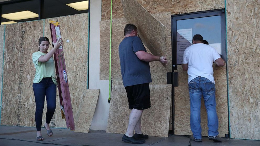
LAKE CHARLES, LOUISIANA- AUGUST 25: (L-R) Lacey Buller, Tyler Arnold and Mike Buller work on placing plywood over the windows of their business before the arrival of Hurricane Laura on August 25, 2020 in Lake Charles, Louisiana. Laura is expected to hit somewhere along the Gulf Coast late Wednesday and early Thursday.
Sheriff Tony Mancuso said that while they could protect property from looters, they can't protect homes from the wind and the storm surge, both of which are expected to be well above the devastating effect that Hurricane Rita had in 2005.
He, too, begged people to leave and leave now.
"There is nothing at my house that is so important in my house that I would stay there," he said. "I would love to leave. It is not an option for me. It is an option for you."
In addition to those leaving in their own vehicles, more than 800 people have been bused out of the area.
12:01 p.m.: Storm is a Category 3 with 125 mph winds
Laura has winds of 125 mph and is forecast to reach 145 mph.
The storm is currently a Category 3 and is expected to reach Category 4 if winds increase as expected.
In an interview with ABC News, Houston Mayor Sylvester Turner said he woke up Tuesday morning to find Laura's track had shifted slightly west and closer to Houston, the country's fourth-largest city with a population of about 7 million.
Officials in Houston and Harris County urged residents to stay off the roads so people evacuating have access to the freeways. Local officials urged all residents in the storm's path to fill up their gas tanks and generators.
The mayor urged people not to panic. City officials said they don't expect Laura to be another Hurricane Harvey or Tropical Storm Imelda, which both led to catastrophic flooding. They do, however, expect this storm to be a fast-moving wind event, which could bring a storm surge, structural damage and power outages.
Compounding the situation is theCOVID-19pandemic, which is why Turner told residents to stock up on necessary food, supplies and PPE. He said he anticipates that COVID-19 testing will be suspended until after the storm and that the city won't be opening mass shelters as it has in years past.
Laura has kept people along the Gulf Coast guessing for days as the projected track continues to change. Forecasters say the storm could strengthen to a Category 4 even before it makes landfall near the Texas-Louisiana border late Wednesday or early Thursday.